Key Takeaways:
- The deadliest 10-mile road stretch in Texas is located in Dallas on I-35E, between Ledbetter Drive and Inwood Road, recording 53 fatal crashes over five years.
- The Dallas–Fort Worth metroplex has the most deadly highway stretches in the state, with 12 segments accounting for a total of 416 fatal crashes during the same period.
- Fort Worth’s deadliest roadway stretch ranked fourth overall with 45 fatal crashes. It lies on I-30 from Granbury Road to Bowman Springs Road.
- Houston’s deadliest highway stretch ranks third statewide, found on I-45 between E Burress Street and E Airtex Drive, with 49 fatal crashes.
- Austin has the fewest deadly road stretches among the largest Texas metro areas, with only one stretch ranking fifth statewide. This segment is on I-35E, running through the city’s core, with 44 fatal crashes.
- San Antonio has two deadly highway stretches, both located on the I-410 loop, though they ranked on the lower half of the list.
- Two deadly stretches are located near Texas’s eastern and western borders: both on I-10, one in El Paso and one in Beaumont.
Texas is home to some of the nation’s largest and most recognizable metropolitan areas, such as Dallas-Fort Worth, Houston, Austin, and San Antonio, each with its own identity and culture. Years of expansion have made these cities and their vicinity neighborhoods desirable to individuals and families looking to relocate. The relatively low cost of living, a growing employment base, and the absence of a state income tax have earned Texas some of the fastest-growing counties in the country.
However, this population influx has also created more traffic on highways and local roads, inevitably leading to more motor vehicle crashes and tragic deaths. According to the Texas Department of Transportation, one reportable crash occurs every 57 seconds on Texas roadways, and one person is killed every two hours and 7 minutes.
To find out which road segments are the most fatal across the state, we analyzed five years of data from the National Highway Traffic Safety Administration (NHTSA). Using a rolling 10-mile window, we identified and ranked the stretches of Texas highway with the highest number of fatal crashes.
Continue reading to uncover our findings.
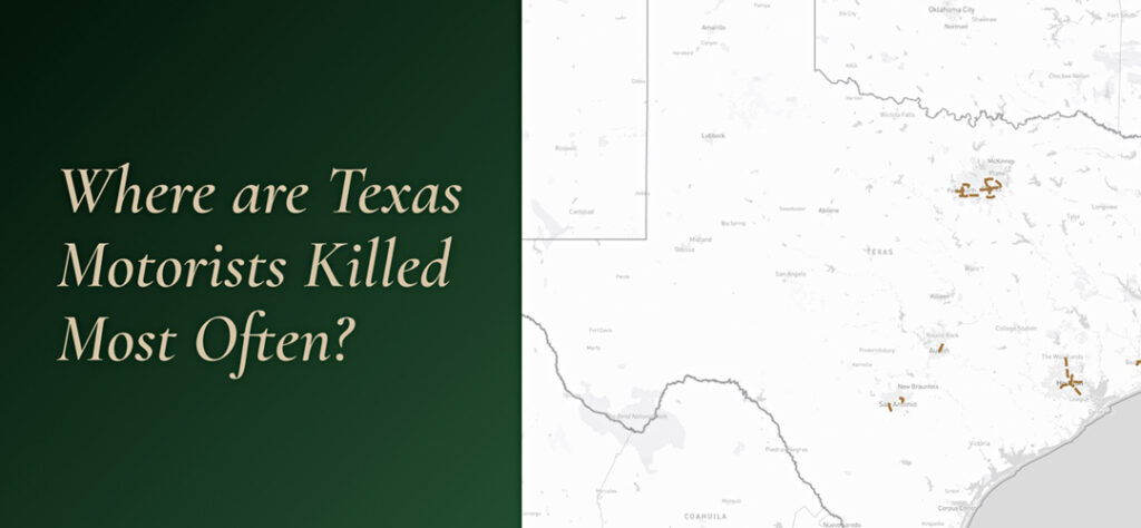
Interactive Map of Texas’s Deadliest Road Stretches
To explore these stretches and their surrounding areas further, refer to the interactive map below. You may zoom in on areas of interest or use the navigation menu to jump to several of Texas’s major metro areas.
*If viewing on a mobile device, rotate for the best experience.
Dallas Dominates the Ranking
Below is a breakdown of the deadliest 10-mile stretches across Texas. For each stretch, we provide the highway name, approximate starting and ending points, the city and county it traverses, and the number of fatal crashes reported over the five-year period.
When multiple stretches had the same number of fatal crashes, those with a higher number of fatalities were ranked higher. If both the crash and fatality counts were identical, the stretches were considered tied.
The Deadliest Road Stretches in Dallas-Fort Worth
The deadliest stretch in the state is a 10-mile segment of I-35E in Dallas, from Ledbetter Drive to Inwood Road, which recorded 53 fatal crashes. This stretch runs through central and north Dallas, cutting through Downtown, the Bishop Arts District, and a major interchange with I-30. The region includes several businesses, well-known tourist spots, and entertainment facilities, resulting in heavy traffic throughout the year.
The second-deadliest stretch in the state also resides in Dallas: I-30 from N Beckley Avenue to Big Town Boulevard, which saw 52 fatal crashes. This segment also crosses central Dallas and continues west past Deep Ellum towards I-635.
In nearby Fort Worth, Tarrant County also contributes several deadly stretches. The deadliest is I-20 from Granbury Road to Bowman Springs Road, which recorded 45 fatal crashes and ranks fourth statewide. This stretch runs through the southern part of the metropolitan area and handles significant traffic from residential and commercial areas. I-35W from I-20 to E Long Avenue recorded 37 fatal crashes, ranking eighth. This segment is a major north-south artery through the city and ends north of the Fort Worth stockyards.
The Dallas area appears six more times in the rankings:
- I-35E from Valwood Parkway to Inwood Road recorded 40 fatal crashes, ranking seventh
- I-30 from NW 7th Street to Sylvan Avenue recorded 32 fatal crashes, placing tenth
- I-635 between Luna Road and US-75 recorded 28 fatal crashes, tying for twelfth place
- I-20 from US-67 to I-45 also tied for twelfth with 28 fatal crashes
- I-635 from Skillman Street to US-80 recorded 27 fatal crashes, tying for sixteenth place
Fort Worth appears three more times in the rankings:
- I-30 from S Cherry Lane to Beach Street recorded 26 fatal crashes, tying for eighteenth place
- I-820 from Mark IV Parkway to Randol Mill Road saw 24 fatal crashes, tying for twenty-first place
- I-20 from SW Green Oaks Boulevard to Lake Ridge Parkway/TX-161, which spans Fort Worth and Dallas, also recorded 24 fatal crashes, tying for twenty-first place
Deadly Road Stretches in Houston
Houston and Harris County contain three of the top ten deadliest stretches. The most lethal stretch is on I-45 between E Burress Street and E Airtex Drive with 49 fatal crashes, ranking third in the state. The stretch lies outside central Houston and provides access to George Bush Intercontinental Airport.
Further south, just beyond the 610 Loop, lies another high-ranking deadly stretch. I-45 from Patton Street to I-610 recorded 41 fatal crashes, placing it sixth. Its central location and access points from other highways keep traffic consistently heavy and create challenging driving conditions.
The Houston area’s third top-ten listing is I-10 from Lathrop Street to Dell Dale Street, which recorded 33 fatal crashes and ranks ninth. This stretch runs from the city’s center and serves east-west travelers.
Houston appears four additional times in the rankings:
- I-45 from Lake Robbins Drive to Cypress Creek Parkway/FM 1960 E recorded 27 fatal crashes, tying for fifteenth place
- I-69 between Bissonnet Street and S Shepherd Drive also recorded 27 fatal crashes, tying for sixteenth
- I-45 from Dixie Drive to Friendswood Road in South Houston recorded 26 fatal crashes, tying for eighteenth place
- I-69 from Commerce Street to E Mount Houston Road recorded 24 fatal crashes, tying for twenty-first place
Deadly Road Stretches in Austin
Austin makes one appearance in the top rankings, but it’s significant. I-35E from Riverside Drive to E Braker Lane recorded 44 fatal crashes in Travis County, making it the fifth deadliest highway stretch in all of Texas. This section of I-35 runs through central Austin and serves as a north-south route through the capital city, ending right past the Colorado River. It handles traffic from downtown, the University of Texas area, and a few residential neighborhoods.
Deadly Road Stretches in San Antonio
San Antonio and Bexar County contribute two stretches to the rankings, both located on the I-410 loop.
I-410 from Stotzer Freeway to I-35 recorded 28 fatal crashes, tying for twelfth place. This segment is part of the major loop surrounding the city and handles heavy traffic from multiple directions. It is also a significant route for employees who commute to and from Lackland Air Force Base.
I-410 from Broadway, situated near the San Antonio International Airport, to I-10 saw 24 fatal crashes, tying for twenty-first place. This 10-mile stretch includes an interchange with I-35 near its midpoint, which may contribute to increased risk due to merging, lane changes, and varying speeds of entering and exiting traffic.
Additional High-Fatality Stretches Across the State
Beyond the major metropolitan areas, two other Texas cities contribute to the rankings of the deadliest road stretches.
El Paso contributes one stretch to the rankings: I-10 from Executive Center Boulevard to Hawkins Boulevard, which recorded 30 fatal crashes and ranks eleventh. This stretch crosses through the city and serves as a major east-west corridor near the Texas-Mexico border.
Beaumont in Jefferson County appears once in the rankings, with I-10 from Walden Road to Mockingbird Drive recording 25 fatal crashes and ranking twentieth. This stretch serves as a major route through Southeast Texas and handles significant traffic from the region’s petrochemical industry and port activities.
Methodology
This study used a rolling 10-mile window to scan major interstates and highways across Texas, identifying the segments with the highest concentrations of fatal crashes over a five-year period (2019–2023). The process was repeated to find the next most deadly stretch, and so on. Crash data came from the Fatality Analysis Reporting System (FARS), a federal database maintained by the National Highway Traffic Safety Administration (NHTSA).
Please note that the start and end points listed are approximate and may not reflect the exact boundaries of each stretch. We selected nearby intersecting roads to give a clearer sense of location. For the most accurate representation, please refer to the accompanying map in our study.
Fair Use Statement
You’re welcome to share our findings. We just ask that you please include a link to the original analysis so others can review the full dataset and methodology.